The Lawrence Hopewell Trail (LHT) will celebrate the next phase of its public history project, “History Along the LHT,” unveiling three new historical signs and hosting a two-mile walk.
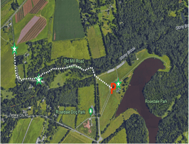
Hopewell Township resident Richard W. Hunter will lead discussion and a walk from Mercer Meadows Park to Old Mill Road and back for history enthusiasts, members of the LHT Saturday Morning Walking Club and the general public on June 25.
The event will begin at 9:30 a.m. at Mercer Meadows’ Rosedale Lake lot off Federal City Road. From there, participants will embark on a two-mile loop to the signs and back, along with members of the LHT Saturday Morning Walking Club.
“Hopewell Valley has a rich cultural heritage spanning natural history, Native American occupation, colonial settlement and farming, the Revolutionary War and beyond,” said Hunter, the president/principal of Archaeologist of Hunter Research Inc. and a former president of the Hopewell Valley Historical Society. “History Along the LHT is an exciting opportunity to help educate the community on this heritage, which contains deep ties to state and national events.”
The three markers that will be unveiled focus on Hopewell’s agro-industrial and ecological heritage centered around the Stony Brook: Chamberlain/McDougald Farm, a local agricultural and community landmark; Reed’s Mill, a gristmill that operated continuously for nearly two centuries; and Rosedale Lake, one of Mercer County’s first parks. Each site highlights an aspect of the local conservation and stewardship ethic, which continues as a cherished practice today.
Hunter will talk about the impacts of milling and farming on the area, providing details and insights about the experiences of these economic and lifestyle pursuits. He will also talk about Mercer County’s creation of Mercer Meadows, which offers a blend of nature and history, along with opportunities for hiking, biking, horseback riding, bird watching, fishing and boating.
“History Along the LHT” is LHT’s new public history project, featuring 31 historical signs along the 22-mile LHT loop, as well as complementary programming. The project has been years in the making and is part of a broader strategy to enhance the trail’s user experience.
In 2016, the trail’s Board of Trustees contracted Hunter Research, a New Jersey historical resource consulting firms, to prepare an interpretive plan with recommendations for sign locations, design and content.
The project was funded by grants from the Mercer County Cultural and Heritage Commission, the New Jersey Historical Commission, the Federal Highway Administration’s Recreational Trails Program through the New Jersey Department of Environmental Protection and an anonymous foundation.
For more information about markers already installed along the LHT, and associated programming, please visit www.lhtrail.org/history.

